Aventura Iberá
Project Team: Jeff Maeshiro, Cassiopea McDonald
Advisors: Christopher Roach (StudioVARA), Sandra Vivanco (A+D), Leonardo Zylberberg (LZ Architect), California College of the Arts
Location: Iberá Wetlands, Argentina
Year: 2013
Location
It is said by 2050, 75% of the world’s population will live in cities, these cities occupying roughly 3% of the planet’s surface. And yet, with currently 1/3 of all urban residents living in slums, it begs the question, what are we doing with the other 97% of the Earth? How do we make living in the countryside economically viable while at the same time preserving local culture and landscape. The defined area of the Iberá wetlands is gigantic, twice the size of Yosemite National Park and 150 times the size of San Francisco. The question is, what patterns and densities of development can this landscape accomodate? Our proposed solution is a new kind of ecotourism that we are naming Aventura Iberá, Wet Land, Wild Life, a network of existing and proposed estancias and tourist sights along three major roadways and lateral horse trails. It’s a productive hinterland, a place of diffuse urbanism where we identify natural and man made networks and deploy permeable buffers and corridors to direct and delimit future growth. In the same way that farmers and ranchers understand the optimal sustainable and economic densities of planting and bovines, we are proposing a solution that will uncover these densities for ecotourism, at three different scales across the project, site-wide, town-wide, and building-wide, in order to manifest a choreographed visual and spatial travel experience.
Conservancy Land Trust
Now, to understand the Iberá Wetlands one must understand the Conservation Land Trust, or CLT, and it’s goals. The CLT is an organization founded by millionaire American Doug Thompkins. His organization’s ambitious and sometimes controversial goal is to create a national park out of the already public land in addition to land they have purchased already. A large part of the wetlands has been designated as a “reserve” by the Argentinian government, outlined here, though 60% of it is still privately owned, and what activities are allowed within this area are limited. For example, all forestry has been banned, so there are vast fields of over-growing un-cultivated pine on site. Now, the CLT has devised a plan for a “scenic route”, that ring’s the wetlands with 11 “portals” as entry points of exploration. Our project encompasses two of them, at it’s center a small, sleepy town of 500 called Villa Olivari.
As we conducted our research and analysis of this territory through a series of mappings and diagrams we identified the following problems:
(1) Chilean pine farms overtaking wetlands without providing economic influx,
(2) a proposed saw mill and industrial port along the Pantanal river that is the subject of great local opprobrium,
(3) the limitations of the Spanish grid for accommodating organic growth,
(4) severed wildlife corridors due to the network of dirt roads and local hunting allowed within the reserve, and
(5) the threat of the loss of local culture due to gentrification and “super-sized” tourism.
One tourism aspect that makes this area stand out is that it isn’t quite as wet a wetland as the rest of the reserve. Other portals have access to extraordinary lagoons, and are situated at the periphery of the wetlands. Ours is a little more marshy, a little dryer, more suitable to cattle ranching and forestry. In order to capitalize on the unique qualities of our portal we have rebranded it Ibera Adventures. A place where adventure tourism helps to market the site but also controls access into and movement across it. A place to not just look at the wild life from afar but to actually camp amongst it, deep in the heart of the wetlands.

Design Model
We were intrigued by the embalsados, which are “floating islands,” unique natural products of the still water of wetland environments. Our design model is based on the way these beautiful shapes are produced. Visualized here: floating particulate planting begin to clump up and form these mats of intertwined roots on which it can eventually sustain larger plants and animals. However, this process follows the high and low ebbs of the wetlands, and in dry times the embalsados sink to the surface below and actually act as a protective sponge for the hydrology, not allowing it to completely seep away. And when the water levels rise once again they are broken up, and begin the process anew. And as we further extrapolated it’s organizational properties we realized they were actually more about densities and networks. Each individual element is nothing until it is within a certain distance or radius from another, at which point they become a network. This expanding, underlying network can then accept other networks to be overlaid onto or inserted into it, both networks being transformed by the process. We also relate the cyclical preservationist operation of the embalsados to the peaks and nadirs of tourist seasons. By developing an open framework for an easy to assemble and disassemble architectural scheme we can the structures and materials in different ways for the differing economic perennial seasons of tourism, fishing and cattle ranching.

Planning
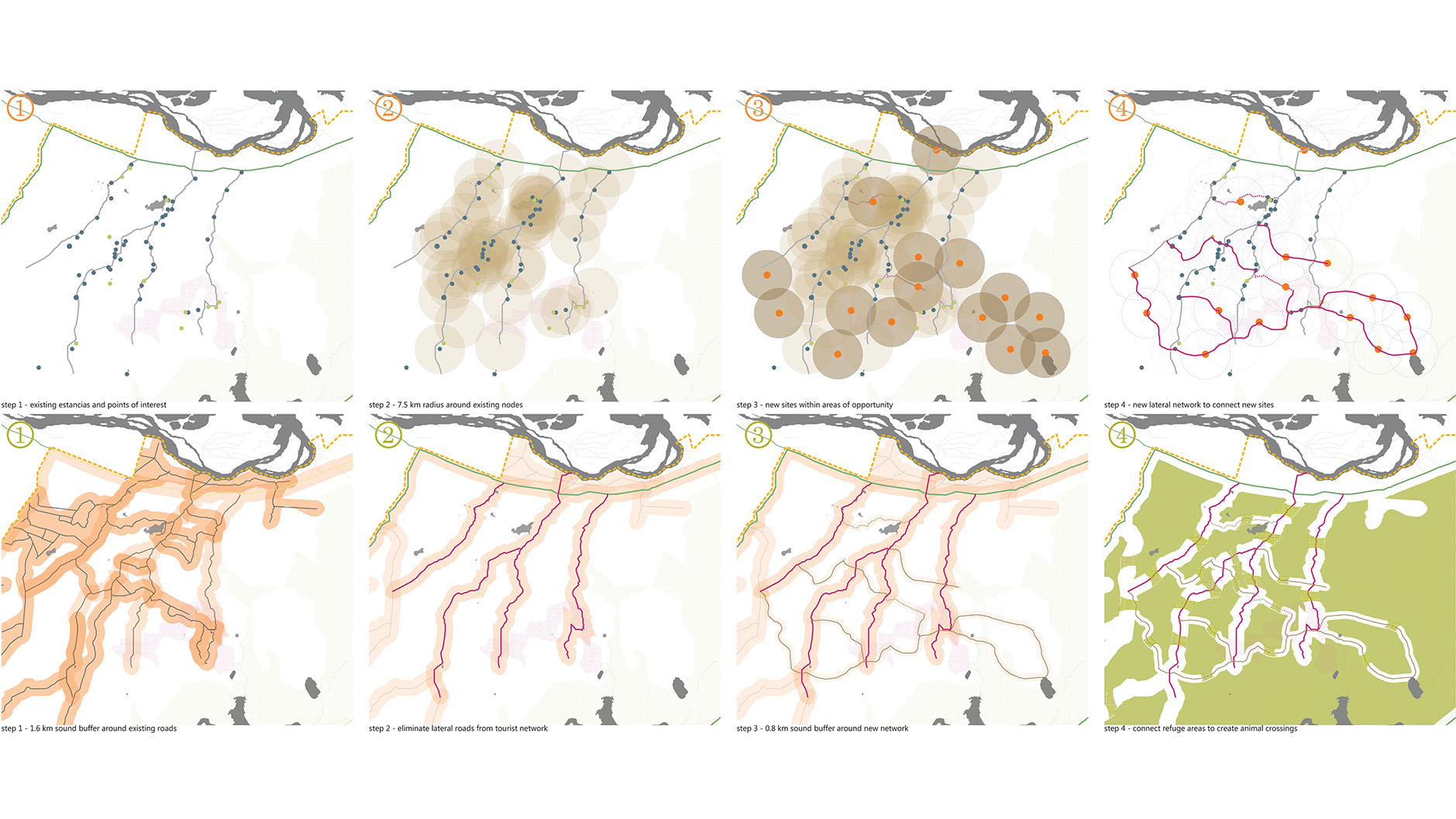
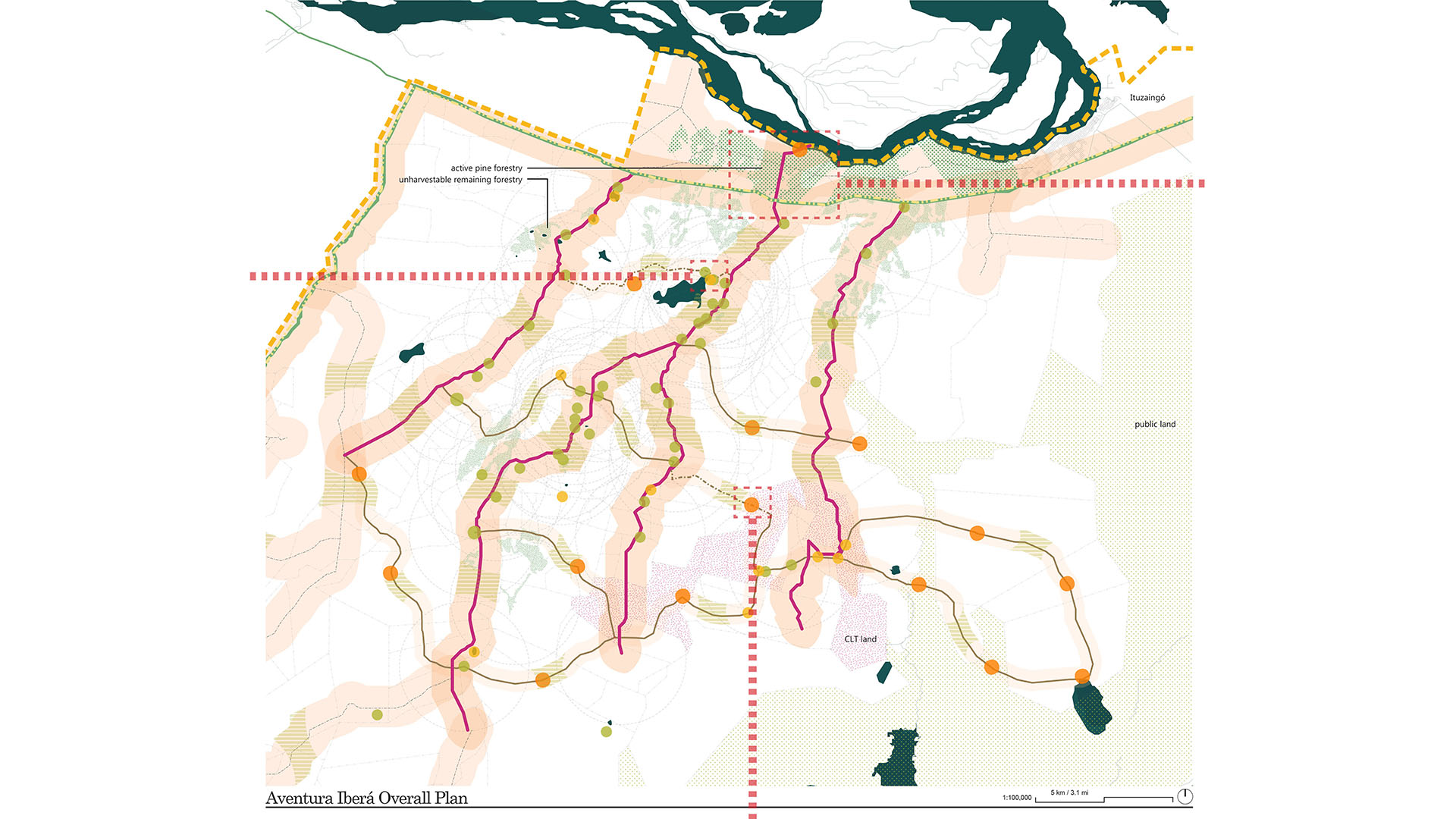
In order to understand the implementation of this system we next focused on key components (or interventions) at three different scales. When it came to the overall site plan we conceived of the initial network as the wildlife habitat and the overlaid network as the existing dirt roads and estancias. By utilizing these roads and establishing a new tourist one we can start to pull people deeper into the wetlands in an effort to use ecotourism to activate the local economy. Initially the properties closest to these tourist migrations will see it in their economic interest to preserve the pristine nature of the Ibera, and as they participate and achieve economic viability, property owners nearby will start to join in as well, a kind of land-transfer strategy encouraging private landowners to participate in the overall preservation project.
We first took a radius of 7.5 kilometers, half a day’s trip by horse, to allow us to discover the areas of opportunity, which then generated a new lateral horse trail network. We then demarcated a one-mile zone around each road, as that is the distance the sound that car engine noise affects wildlife, as well the general area in which local hunting occurs. By making these lateral roads off limits to non-local car traffic, it leaves these the three major longitudinal roads as the only automobile access. By then inserting our proposed lateral horse trail network (which has only a half-mile sound buffer) we can see the areas wildlife would naturally gravitate to. We then propose a series of wildlife corridors across the tourist network. These armatures are completely off limits to hunting, and demarcated by special entryways, containing car bridges over intermittent portions of the roads to allow for animal crossing and wetland continuity. These corridors are made using 20% private property easements, as shown here, creating animal “right of ways”. This also closely mimics the way we envision ecotourism in general influencing private owner participation in the ecotourism.
The origins of the horse trail network stem from the idea of utilizing changes in transportation type to strain movement through the site. First, from car or bus to 4×4, because the existing dirt roads there are too rough hewn for normal vehicles, then to horseback to foot and even kayak. This transportation transfer allows us to detail the types of experiences tourists may have there. Differing durations of trips allow for a variety of visitor types. The more adventurous one is the more they will be able to experience the culture and wildlife. We have mapped these differing trips on our “line” map here, outlining the different tourist circuits, the EXCURSION line in blue, TREK line in yellow, and ADVENTURE line in red.

Township Scale
The next scale is the township scale, exemplified here by Villa Olivari. Here is our site map for Villa Olivari and it’s connection to the proposed industrial port along the Pantanal river. Our counter proposition is to develop it as a beach front property, dubbing it Playa Aventura, similar to the successful Playa Familiar down the road at Ituzaingo. By connecting the wonderful sandy beaches and apparently epic tiger-catfish catching opportunities to the rest of the tourist network of Aventura Ibera, we hope to not only diversify the range of experiences possible across the site but also to use the land-transfer strategy of intensified economic activity to raise land prices at the port and along the route there to make commercial forestry and the possibility of an intensely polluting port or sawmill to become infeasible so near the town and this beachfront.
In order to direct growth on this township scale we needed to apply the same buffer and corridor strategy from the overall site plan scale. At this scale, our main goal is to utilize the eco-tourist infrastructure to act as the buffer or preserver of the wetlands. So here, we’ve detailed our strategy for dealing with the urban scale: first is to scan for the existing networks (in this case, the local population). By pinpointing concentrations of activity or program we can understand movement patterns, as well as the buffer of offset from the wetlands that we consider permissible (in this case, the actual thickness of the ecotone). By then inserting the seeds of our next network (in this case, tourist bus/car parking, a visitor’s centre, and lodging) we can start to influence the existing network using the idea of activated radii (in this case, how far a tourist would be willing to walk before they need some sort of visual or programmatic stimuli, in our estimation 100 meters). This helped us to plot out initial light program, such as restaurants and goods shops, to further integrate the two networks. Eventually, along these movement routes opportunities for local businesses to participate will begin to congeal, and using the same land-transfer strategy, will start to allow access along tourist “lines of desire”, breaking down the rigidity of the Spanish grid. We see growth occurring here in three phases, but one of the most important aspects of the earliest phase is this system of walkways along the wetland edge. In the beginning it’s to be a park and system of raised walkways, a kind of boardwalk edge for tourists and locals to use but will eventually define the outer extents of the city. As local and tourist program eventually fills in in the area the Spanish grid will have to negotiate with this new edge, though whether it continues the same rigidity or begins to more organically negotiate it is up to the local people.
We have replicated this same strategy in a number of smaller scale interventions within our site, one of which is a lagoon that connects three estancias. This site is a perfect opportunity to learn about local gaucho culture, or start a horse trek, as well as enjoy a ride on a kayak, experiencing the wetlands from the surface of the water. Here, the existing network is the ranchers and the movement of cattle and wildlife between wetlands. By seeking not to disturb these networks we’ve developed radii of social and walking distances to disperse program towards the wetlands: parking to kayak storage, to a gathering space for group meals of asado prepared by the estancia, to public showers, to the lightweight lodges that sit along the ecotone; they become the interface between tourist and wetland.
In order to concretely direct the visual language of Aventura Ibera we have come up with a construction methodology that will do triple duty: we will use the existing and unused pine trees within the reserve as our base material while simultaneously converting fallow land for productive agriculture or wetland reclamation (a kind of decommissioning of the forestry); it is a building system that is based on the language of vernacular architecture, meaning unitized and stacked; and it allows for the structures to be easy to assemble and disassemble, allowing them to be moved for other purposes or reused in other structures or even be allowed to become relics in the wetlands, becoming natural aviaries that slowly disintegrate back into the ground.
The formal development of the architectural typology is based on incorporating the spatial interventions of program onto the construction network. Program areas distort the structure, twisting for views, reconstituting the wall for privacy. In this case the program is multiplied in the same way to create a duplex. Through this strategy these structures can be deployed across the site, being reinterpreted and reconstituted with every new tourist season.